


ClimateAverage weather that a location has over a long period of time is the average weather that a certain place has over a period of at least 30 years; however, the climate of an area might not change over hundreds of years. Location on the earth, bodies of water, and land features such as mountains, play a major role in determining the type climate an area has. The circulation of air around the world also affects all the climates of the world.
The warmest part of the earth is in the tropics• At or near the equator
• Hot weather all year where the sun’s rays shine directly down at noon every day during every season. The weather in the tropics is hot all year long.
Warm air holds moisture, and warm air also rises. As the warm, moist air rises from regions around the equator, it blows toward the poles. The closer an area is to the North Pole or South Pole, the less direct (more slanted) the rays of the sun are, and the colder it is. Cool air is pulled back toward the equator to replace the warm air that has risen into the atmosphere. At the same time, the rotation of the earth causes winds to be turned so that they blow in different directions, depending on the location. WindAir in motion is air in motion. In North Dakota, the prevailing windsMost common that bring moisture tend to blow from the west.
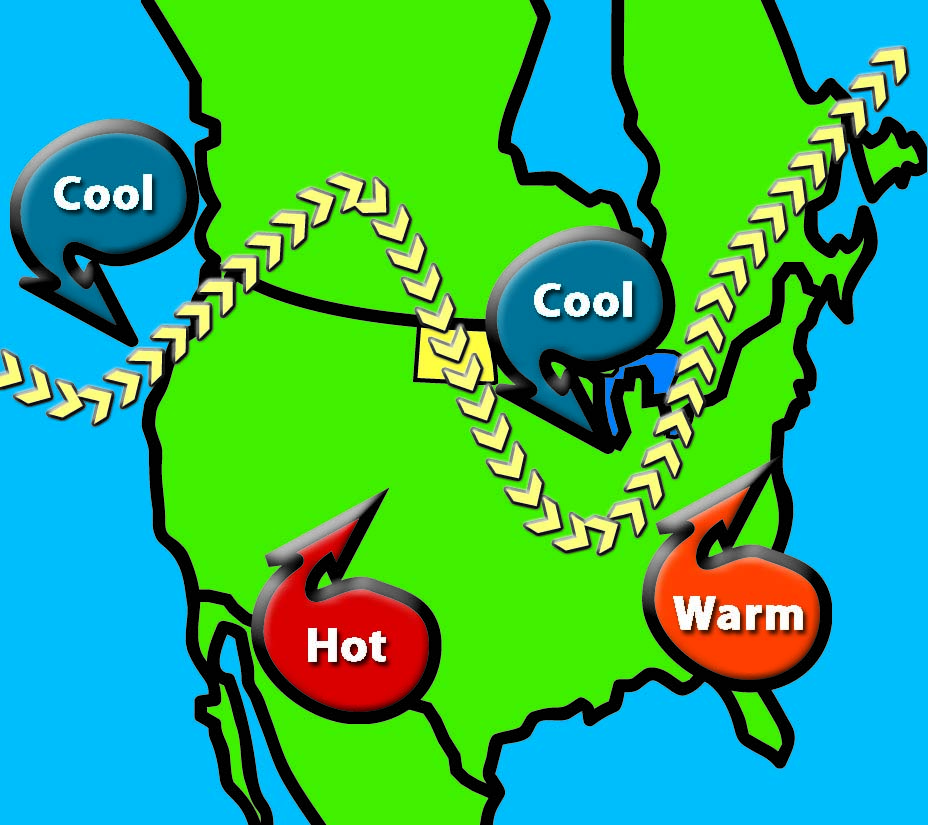
Figure 67. The Jet Stream. (SHSND-ND Studies)
North Dakota ranks in the top three states with the most wind. Wind does not always move in a straight line, but it also moves upward, downward, and sideways. Winds can become violent, as during severe thunderstorms and tornadoes.
About six to eight miles above the earth, there is a fast-moving current of air that affects weather and climate in North Dakota and other areas. This jet streamA fast-moving current of air that affects weather and climate that flows from west to east can be over 1,000 miles long and over 150 miles wide. It is like a river of air that can move over 250 miles per hour. The jet stream separates cold ArcticNorth Pole Region air from warm southern air. The farther south the jet stream is, the more cold air is able to move down to the state from the frigid Arctic region. When the jet stream is located farther north over Canada, warm air from the Gulf of Mexico is able to move into the state. This is common during the summer and also during very mild winters.
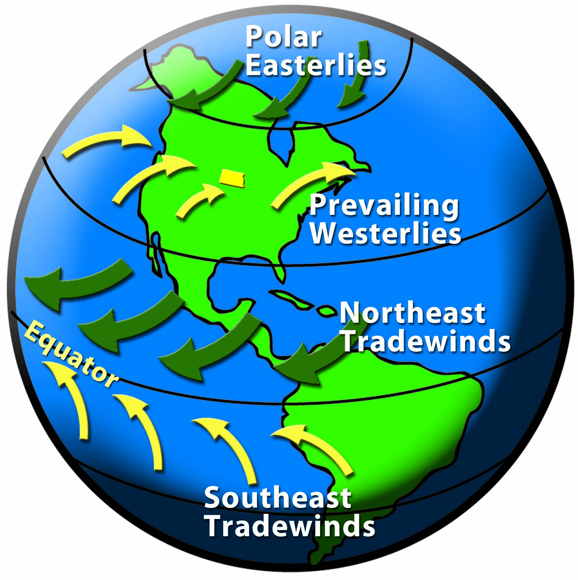
Figure 68. Prevailing Westerlies. (SHSND-ND Studies)
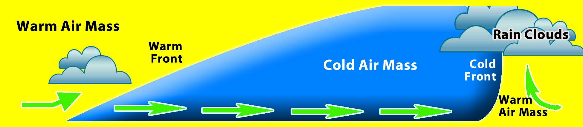
Figure 69. Air Masses Collide creating stormy conditions. (SHSND-ND Studies)
The Rocky Mountains in the western part of North America block the prevailing westerly winds that bring moisture from the Pacific Ocean. For this reason, the temperature and moist air masses from the Pacific are changed to become warmer and drier before they reach North Dakota.
No mountain barriers exist between North Dakota and the cold North Polar region; therefore, cold air masses can easily move down, blasting the state with cold air. In the same manner, the lack of mountains between North Dakota and the Gulf of Mexico allows warm, moist air from the tropics to enter the state.
During every season, air masses from the Pacific, Arctic, and Gulf of Mexico enter North Dakota many times, causing rapidly changing weather. When cold air masses and warm air masses collide, they do not mix. The warm air rises over the cool air, creating stormy conditions.
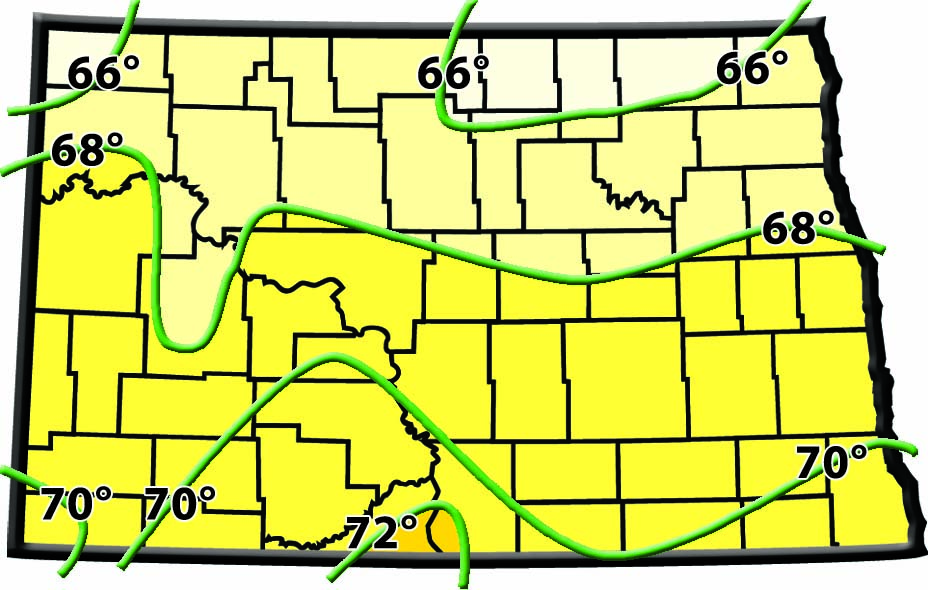
Figure 70. Average July Temperatures. July is the warmest month in North Dakota. (SHSND-ND Studies)
The climate is different in the eastern part of the state than it is in the western part. Eastern North Dakota gets much more moisture than does western North Dakota. The Red River Valley usually has more humidity than other parts of the state, so summer days may feel warmer, and winter days may feel colder.
The Red River Valley has more wind than other parts of the state. Temperatures also vary quite a bit from east to west, and especially from northeast to southwest. In northeastern North Dakota, the temperatures are usually much lower than they are in the southwestern part of the state.