


North Dakota has a geographical feature that many people do not know about—a continental divide.Line that separates river systems that flow to opposite sides of the continent A continental divide is a line that separates river systems that flow to opposite sides of the continent. This line is shown in yellow on the map below.
The largest and best-known continental divide in North America is the Great Divide, located at the crest (top) of the Rocky Mountains. This is an east-west continental divide. On the east side of the Great Divide, the rivers all flow to the Atlantic Ocean, and on the west side the rivers flow to the Pacific Ocean.
Many people think that a continental divide must be located in mountains, or at least on high ground, but this is not true. The position of North Dakota’s continental divide is on fairly level land, and it cannot be seen. Nevertheless, the rivers located on either side of this line will never join each other, and the water in these rivers will end up on opposite sides of the continent.
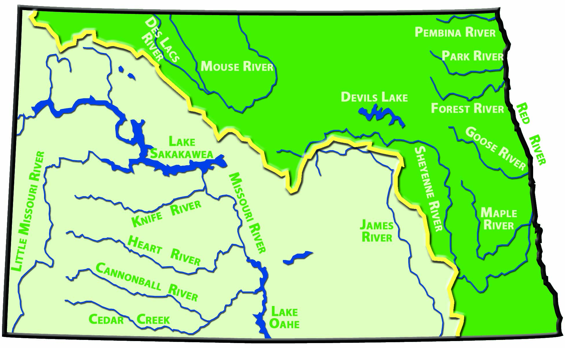
Figure 44. Northern Divide. The major rivers of North Dakota are shown on this map. (SHSND-ND Studies)
North Dakota has three drainage systems: the Missouri River with its tributaries, the Red River with its tributaries, and the Mouse River with its tributaries. The continental divide in North Dakota, called the Northern Divide,North-south continental divide in North Dakota is a north-south continental divide. Waters to the south and west of this divide (the Missouri River and its tributaries) flow into the Gulf of Mexico, and waters to the north and east of it (the Red River and the Mouse River with their tributaries) flow into Hudson Bay in Canada.
Some of the main tributaries of the Missouri River in North Dakota are the James, Little Missouri, Knife, Cannonball, and Heart Rivers. The Missouri River joins the Mississippi River, and the Mississippi River flows into the Gulf of Mexico.
The Sheyenne River is the biggest tributary of the Red River in North Dakota. Other tributaries of the Red include the Goose, Pembina, and Forest Rivers. The main tributary of the Mouse River in North Dakota is the Des Lacs River. The water from both the Red River and the Mouse River with their tributaries ends up in Hudson Bay.
Rivers, such as the James and Sheyenne, are separated by only a few miles in some places. Their waters, however, will never mingle, and finally will end up about 3,000 miles apart because of the continental divide called the Northern Divide.

Figure 45. The Pembina River and Gorge. (ND Tourism)